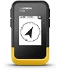
| Product Dimensions | 13.97 x 5.84 x 2.79 cm; 308 g |
|---|---|
| Item model number | ZL180 |
| Batteries | 1 C batteries required. (included) |
| Display size | 2.4 Inches |
| Battery Life | 20 Hours |
| Voice command | Touchscreen |
| Manufacturer | NiesahYan |
| ASIN | B0DKWTVP17 |
-
-
-
-
-
-
-
3 VIDEOS -
Image Unavailable
Colour:
-
-
-
- To view this video, download
ZL180 Handheld GPS for Surveying, High Precision Rugged Land Surveying Equipment for Ranches, Garden, Farmland and Parking Area Distance Measuring
Purchase options and add-ons
| Brand | NiesahYan |
| Model name | ZL180 |
| Vehicle service type | Car, Truck |
| Screen size | 2.4 Inches |
| Special feature | Waterproof |
| Connectivity technology | USB |
| Map type | Topographic |
| Included components | USB cable, instruction manual, portable rope |
| Battery life | 20 Hours |
| Mounting type | Handheld |
About this item
- HIGH PRECISION ACCURACY: 2 high sensitivity satellites global GPS + GLONASS coverage for reliable surveying around the world, support for fast positioning and a reliable signal,area measurement error in 0.003 acres,it cannot be used for saving waypoints and navigation
- LARGE LCD: Our Product has a 2.4 inch FSTN panel and equipped with LCD backlight display, the measurement results can be displayed on the screen directly, convenient for observation
- RUGGED DESIGN: Our Product has a weight of approximately 180g/6.3oz and is compact, making it easy to carry. Adopts humanized groove design, easy to hold and not easy to fall off when using
- 4 IN 1 MEASUREMENT: 2 types of area measurement methods that can measure garden parking lot ranch and flat field.2 distance measurement that can measure straight and curve line distance
- !!! PLEASE NOTE:Please search satellite signals in an open outdoor area before using this device and there is no signal can be found indoors.When the signal value in the upper left corner of the device screen is below 1 m, start measuring to ensure the accuracy of this device
- TIPS: Recommended to measure an area above 0.16 acres and distance above 328 ft. The larger the measurement range, the smaller the error.The device needed to be held horizontal when measuring
- NOTE:The altitude data displayed on the device is GPS altitude, and it changes with Satellite Signal.This is normal!This device only be used for surveying land and cannot be used for saving waypoint and navigation
Frequently bought together
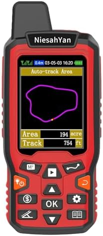
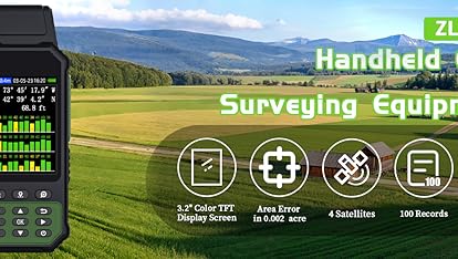
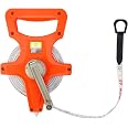
Videos for similar products
Product Description
Product details
- Batteries : 1 C batteries required. (included)
- Product Dimensions : 13.97 x 5.84 x 2.79 cm; 308 g
- Manufacturer : NiesahYan
- ASIN : B0DKWTVP17
- Item model number : ZL180
- Customer Reviews:
Product information
Technical Details
Additional Information
| Customer Reviews |
4.1 out of 5 stars |
|---|---|
| 鶹 Rank |
|
| Date First Available | Dec 4 2024 |
Feedback
From the brand
-
-
-
-
-
How do we start?
Our team consists of a group of engineering professionals whose constant exploration of new technological areas ensures that our products are at the forefront of the market.
What makes our company unique?
We firmly believe that product quality is the key to our success. This is a core belief that we have always held and it permeates all our decisions and actions.
Why do we love what we do?
Providing cost-effective GPS measuring tools and handheld GPS units for consumers around the world. Just give up the complex labor-intensive tools and making people's lives easier!


