


| OS | [Predicted] Système d'exploitation Garmin embarqué |
|---|---|
| Product Dimensions | 17.88 x 13.82 x 5.82 cm; 217.72 g |
| Batteries | 2 AA batteries required. (included) |
| Item model number | 010-02451-10 |
| Connectivity Technologies | ANT+ |
| Special Features | Bluetooth |
| Other display features | Wireless |
| Human Interface Input | Buttons |
| Scanner Resolution | 160 x 240 |
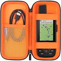
| What’s in the box? | GPSMAP 65s; USB cable; Carabiner clip; Documentation |
| Item Weight | 218 g |
Frequently bought together
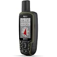
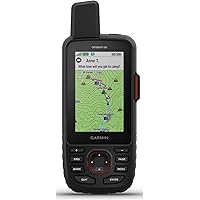
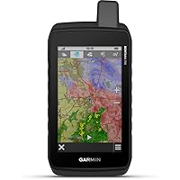
This item: Garmin GPSMAP 65s, Button-Operated Handheld with Altimeter and Compass, Expanded Satellite Support and Multi-Band Technology, 2.6"" Color Display
$539.99
Get it by Saturday, Nov 15
In Stock
+
$23.99
Get it by Saturday, Nov 15
In Stock
+![VRWOX [2-Pcs] TPU Screen Protector For GPSMAP 65S 65SR Handheld TPU Screen Protector,Full Coverage HD Clear Hard Plastic Anti](https://images-na.ssl-images-amazon.com/images/I/51lR8htqJML._AC_UL116_SR116,116_.jpg)
$12.00
Get it by Saturday, Nov 15
Only 7 left in stock.
Total price:��$00
To see our price, add these items to your cart.
Choose items to buy together.
Product information
Additional Information
| ASIN | B08HR5CXCK |
|---|---|
| Customer Reviews |
4.5 out of 5 stars |
| �鶹�� Rank |
|
| Date First Available | Sept. 24 2020 |
| Manufacturer | Garmin |
| Place of Business | Olathe, KS 66062, US |
Feedback

What do customers buy after viewing this item?
Page 1 of 1 Start again
Bestselling
in this set of productsGarmin Etrex 32X, Rugged Handheld GPS Navigator (010-02257-00)FREE ShippingGet it Nov 18 - 20Only 6 left in stock.Highest rated
in this set of productsGarmin GPSMAP 66i, GPS Handheld and Satellite Communicator, Featuring TopoActive Mapping and inReach TechnologyFREE Shipping by �鶹��Get it by Saturday, Nov 15Only 2 left in stock.Lowest price
in this set of productskwmobile 2X Transparent Screen Protector Compatible with Garmin GPSMAP 62 / 62sc / 64 / 64st/ 65 / 65sr Film - Clear Protective Screen Cover Kit for GPSFREE Shipping by �鶹��Get it by Sunday, Nov 16Only 3 left in stock.- Garmin Montana 700, Rugged GPS Handheld, Routable Mapping for Roads and Trails, Glove-Friendly 5" Color Touchscreen (010-02133-00)FREE Shipping by �鶹��Get it by Monday, Nov 17Only 6 left in stock.
- Garmin eTrex® SE GPS Handheld Navigator, Extra Battery Life, Wireless Connectivity, Multi-GNSS Support, Sunlight Readable ScreenFREE Shipping by �鶹��Get it by Saturday, Nov 15Only 5 left in stock.
- Supershieldz (2 Pack) Designed for Garmin GPSMAP 67 67i 66i 66s 66st 66sr Tempered Glass Screen Protector, Anti Scratch, Bubble FreeFREE Shipping by �鶹��Get it by Thursday, Nov 13


From the manufacturer

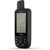
Garmin GPSMAP 65s
Multi-Band/Multi-GNSS Handheld with Sensors

EXPANDED GNSS SUPPORT
Multi-band technology and expanded GNSS support (GPS, GLONASS, Galileo, QZSS and IRNSS) provide optimal accuracy in steep country, urban canyons and forests with dense trees.

ABC SENSORS
Navigate every trail with ABC sensors, including an altimeter for elevation data, barometer to monitor weather and 3-axis electronic compass.

PRELOADED TOPO MAPS
Preloaded TopoActive U.S. and Canada maps show you terrain contours, topographic elevations, summits, parks, coastlines, rivers, lakes and geographical points.

PUBLIC LAND BOUNDARIES
An optional display of federal public land boundaries on topographical maps helps you know that you’re venturing where you’re supposed to be.
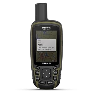
SMART NOTIFICATIONS
Receive emails, texts and alerts right on your handheld when paired with your compatible smartphone.

GARMIN EXPLORE APP
Plan, review and sync waypoints, routes and tracks by using the Garmin Explore website or app on your compatible smartphone. You can even review completed activities while still in the field.
Brands in this category on �鶹��
Sponsored


